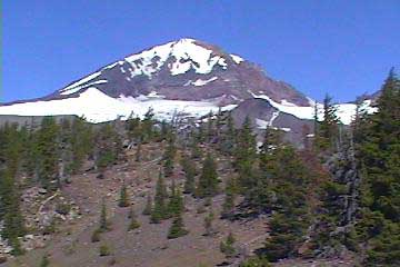
Middle
Sister - North Ridge (Pole Creek Trailhead)
...Continued from Page 1
Somehow I made it without
mishap, and set out to traverse Hayden Glacier to the far side, where
I could now see the destination ridge far on the other side.There were several large crevasses opened up
on the glacier, but they were easily avoided (no glissading, I
guess!).The snow was
fairly soft, and I was able to traverse the glacier without much
problem.As I finally
reached the ridge, now at
12:30 , after my planned
summit time, I saw a group of climbers descending.They told me that this was a good trail and that I was almost
there.They also said that
if I couldn’t follow the trail, to stick to the ridge.This was the first group of climbers I’d seen in the six and a
half hours I’d been on this “trail”.For what was supposed to be a fairly popular climb, I had the
place all to myself.
Encouraged by the climbers, I headed up the north ridge of Hayden
Glacier (staying to the left of the ridge, as the right side has a
very steep drop), where I ran out of water.I figured I would, as I had already hiked over thirteen miles
and had expired a ton of wasted elevation gain, not occurrences I had
counted on when packing.
However, I simply pulled out my stove, melted and filtered some snow,
and continued on.The time
was now
1:30pm , and I was worried
that I wouldn’t have time to summit.I pressed on, exhausted now, until I reached the saddle at
around 9,000 feet.When I
arrived at the saddle, I got a phone call from Sandra, who was in
Sweden
visiting family.“Where
are you?” she asked.
“9,000 feet on Middle Sister, I responded.”“What?” We talked for
about fifteen minutes, and as we chatted, I was enveloped by swarms of
butterflies.Literally
thousands of butterflies filled the skies all around me as we talked
on the phone.I must have
been right on the migration route for the Monarch flight to
Mexico
.That was a really
cool experience.I hung
up, and began the trek up the final pitch to the summit.
Rockfall was nearly constant on
the East side, as I trotted up the cinder “trail”.The trail was hard to follow, and the ridge was very narrow,
only a few feet wide, with steep
drop-offs on either side.
I wasn’t so sure this was a good idea, as I had no rope or protection
(I had heard this called the “dog route”).The pitch grew much steeper, as the trail vanished, and I ended
up making class 5 moves up sheer faces, trekking poles in one hand,
the other grasping at any rock that was actually stable.I was really nervous now, as a fall would be really painful (if
I was lucky).I was
cursing the climbers who called this a “good trail”, and looked for a
way down.It was clear
that going down would be really dangerous, so I figured that I must
have lost the trail when it went around a crevasse, (I stuck to the
ridge like the other climbers had told me) and that I could follow it
on the way down.I
eventually made it up the rocky slope, where the trail resumed,
following a two-foot wide ridge with sheer drops on both sides, with
the east side crumbling away.After a bit of class-3 bouldering, I finally made it to the
summit.
There was a group up there
drinking champagne after ascending the southeast ridge, where I was
sure I should probably have gone.I sat for a few moments to regain my composure after the really
freaky last pitch. The summit was small, with only one real spot to
sit, where the other group was (much different experience than
Mt.St. Helens
, where we all napped at the summit, and lounged for two hours). The
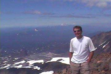
weather was fantastic, at 80 degrees and clear skies.The entire Oregon Cascade Range was visible from the summit, as
well as
Mt.Adams
in
Washington
, and
Mt.Shasta
, barely visible in the distance to the South.I could also see the forest fire burning near
Madras
, where 18 homes had been destroyed yesterday.It was now
3:30pm , and after a few
quick snapshots by the other climbers, I knew I needed
to head back if I was going to reach the car by dark.I was exhausted, and hungry (I’d eaten all my food except for a
few protein bars, which I just couldn’t stomach), and was thinking of
descending with the other climbers down the southeast ridge, as the
idea of the descent down my trail was not fun.However, I noticed the now nearly empty bottle of champagne,
and the nonexistent trail down the southeast ridge, just loose rock
like on the east ridges that I had been on, and figured I was better
off heading back the way I came.I started down, and the trail was easier to follow on the way
down.However, the
trail was still fairly treacherous, and about halfway down, it
disappeared, and I had to traverse a steep rock slope to make it back
to the ridge, as rock fell away beneath my feet.I made it back to the trail in one piece, and headed back down
to the saddle.I couldn’t
believe that I had just climbed the “dog route”!I had climbed routes of similar claimed difficulty on South
Sister,
Mt.Adams
, and
Mt.St. Helens
, and none had been the least bit technical or scary.This one sure was!
Maybe with the ridge covered with snow, it’s not as bad, or maybe
completely barren, but with patches of ice and small crevasses, along
with the cinders, ash, and loose rock, it seemed downright technical
at the top, and I should have had a rope on for sure.
I plunge stepped down the
glacier, and followed the footsteps in the snow to the real climbers
trail.The trail was
cinders and ash, as on the South Sister Trail, and disappeared often.It was not marked or maintained, and was a cinder slog for the
entire return to the third creek, where I found out that if I hadn’t
crossed the creek and followed the Camp Lake trail, but instead had
taken an indiscernible, unmarked trail to the right just
before crossing, I would have been on the right track.Just make sure you don’t cross the third creek if you want to
climb the north ridge!I
didn’t feel too bad about missing the trail, because if you have
directions that tell you otherwise, and you have never been there
before, it is almost impossible to think that this little drainage
area is actually a trail.
I had seen it, but thought it was just a place where water drained
down into the creek, not a trail!I continued back, trying to outrace the mosquitoes, as my legs
were collapsing beneath me.I finally reached the trailhead at around
7:30 , about a 14-hour
hike, ranging over 24 miles, and over 7,000 feet of elevation gain.Still cursing my directions, I sped over the washboard gravel
road, and made it back to Sisters in time to catch some Mariachi and
incredible Mexican food at the only Mexican restaurant in town.Try the house specialties!
For more information about climbing Middle
Sister: