Our Take: |
The Riverside Trail winds along the banks of the Clackamas River for
it's entirety. It offers many views of the river, and many places
to stop and take a break at river's edge. The trail does have
some ups and downs, and does have a few places where it's a little tight
getting around the corners, particularly where the hillside is exposed.
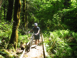
In between, there is lots of fun, zippy singletrack.
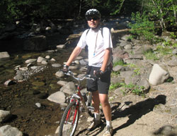
Almost immediately, you cross a creek bed, where
inexperienced riders will
 have
to carry the bike across. Then just up ahead is the first of several
wooden bridges - this one is easy to ride across, some others require
a carry. For experienced riders in good shape, there are very
few places you'll have to carry or hike-a-bike on this trail.
For us out-of-shape sorts, we did have to walk several times to make
it up some of the hills, but never too far, and a fun stretch almost
always followed. have
to carry the bike across. Then just up ahead is the first of several
wooden bridges - this one is easy to ride across, some others require
a carry. For experienced riders in good shape, there are very
few places you'll have to carry or hike-a-bike on this trail.
For us out-of-shape sorts, we did have to walk several times to make
it up some of the hills, but never too far, and a fun stretch almost
always followed.
Sandra didn't like the amount of rocks and roots
on the trail, nor the exposed areas and tight squeezes - I found them
exciting and had a blast. After about half the trail's length,
she had had enough, and wanted to turn back - too bad because I thought
it was a lot of fun - zippy singletrack, lots of short ups and downs,
enough obstacles to make it interesting, but not so many we had to walk
it. Some of the best views and stops in the trail were still to
come, so we didn't get to enjoy it to its full extent.
Bottom line, I guess, is that experienced riders
who don't mind the small obstacles will probably love this trail - it's
not difficult, and if you have good control of your bike, you won't
feel at all uncomfortable about the little bit of cliff-hugging.
There is a lot of potential fun here. However, new beginners might
wish they'd made another choice due to the rocks, roots, narrow tree
splits, and other intermediate maneuvers that having fun on this trail
will require. Heck, it's almost worth visiting just for the beautiful
drive along Highway 224, watching the kayakers and rafters having a
ball on the river.
|


 From Portland, take Exit 12A Eastbound off of I-205
to Estacada and Clackamas via Highway 212. Follow Highway
212 for 3.5 miles through Clackamas, and follow Highway 224 to the right
where there is a junction. Follow Highway 224 SE for 39 miles,
snaking along the beautiful banks of the Clackamas River, to where a
small bridge crosses the Oak Grove Fork of the river.
From Portland, take Exit 12A Eastbound off of I-205
to Estacada and Clackamas via Highway 212. Follow Highway
212 for 3.5 miles through Clackamas, and follow Highway 224 to the right
where there is a junction. Follow Highway 224 SE for 39 miles,
snaking along the beautiful banks of the Clackamas River, to where a
small bridge crosses the Oak Grove Fork of the river.