Follow US-20 to Sisters, OR.From Sisters, take State Highway 242 westbound to Mackenzie
Pass.Take OR-242 for
miles, before turning left onto Forest Road 15.Forest Road 15 is at first paved, but quickly gives way to
trademark central
Oregon
washboard gravel.Follow
the road for 7.1 miles, keeping left at the “Y” junction (follow the
sign to Pole Creek Trailhead), and continue until the road ends at the
parking area for the trailhead, shortly after milepost 10.Watch out for deer on this road.There were several jumping out of the forest as I sped over the
washboard gravel, trying to salvage what was left of my van.
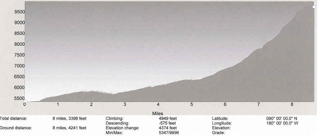
To view the
elevation profile along the Pole Creek Climber's Route,
click on the image below.
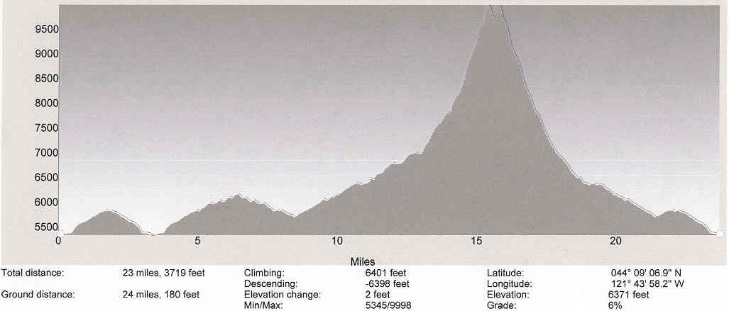
To view the
elevation profile of the route that I took on my summit trip,
click on this image!
Trip Report:
Only two weeks after swearing I
was never climbing another volcano in the summer (following the South
Sister cinder slog), I found myself in
Bend
on business.I was alone,
and the mountains were beckoning me.I figured what the hell.I was planning to take the Obsidian Trailhead, but I found out
at the last minute that there is a Limited
Use Permit that you have to get in advance from the ranger station.Since there was no such permit to use the Pole Creek trailhead,
I opted for that route.I
arrived at the trailhead around
5:00AM , and quickly filled
out my self-issued permit, and hit the trail.After 1.5 miles, there is a 3-way junction with the Pacific
Crest National Scenic Trail.At this point, I realized that I had forgotten my camera.I was going to solo this mountain, so I would have nobody to
share the experience with, and no photos!What was the point?
So, I cruised back down the trail and got the camera, a necessary
3-mile detour.I arrived
back at the intersection, and looked at the directions I had printed
off the internet.“At 1.4
miles, turn right and follow for 0.6 miles” it said.OK, I headed off to the right.After a mile passed by, and no other trail presented itself, I
checked my map and compass, and realized that I was on the Pacific
Crest trail, heading northwesterly.So, I headed back to the intersection after a wasted 1,000 foot
elevation gain.Now 6.5
miles into the trip, at milepost 1.5, I was on the right track.Luckily I was hiking fast, so it was still only about
6:30 .
I descended down the
GreenLakes
trail, and crossed a couple of creeks along the way.
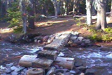
The first creek had a nice log crossing (seen below), but watch your
step on the second one. I was glad I had trekking poles
for balance as I teetered on wet rocks and logs to cross.Amazingly, I didn’t fall in.The trail is well-maintained in this area, and quite pleasant
to
hike on, much unlike the South Sister Climbers Trail.After the second creek, however, the mosquitoes moved in.I quickly responded with DEET, but still they hovered around me
annoyingly.The directions
I had said to turn right on the Camp Lake Trail after crossing the
creek.There was a sign
after the second creek that indicated the Green Lakes Trail went left,
and the
ChambersLakes
trail went straight.Hmmm.I headed toward
ChambersLakes
, since I was heading the right general direction.Soon, I came upon a third creek.This one was a bit bigger than the previous two, but I saw a
sign to
CampLake
on the other side, so I knew I was on the right track.I crossed the third creek, and followed the sign to
CampLake
.The trail switchbacked
and then disappeared entirely.I hiked cross-country over large rocks, deer trails, and some
class 4 moves, as I searched for a trail.The directions said to head west, which made sense, since I
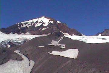
could see Middle Sister and North Sister, and headed for them.
Eventually, I hit a meadow,
where a large group of campers were doing Yoga.I asked them if I was on the trail, and they said that the
trail was on the ridge to the South.I thanked them, and headed cross-country once again, climbing
the ridge, and finding the trail.I followed the trail west for a mile or so, until it turned
sharply south.I was much
closer to South Sister than the saddle by now, and I realized that the
trail that they had pointed me to must have been the
ChambersLakes
trail, which heads up South Sister.I headed now straight for the saddle, climbing ridges, and
breaking new ground, cursing my directions.I finally ascended another ridge, and was standing on top of a
cliff, with a deep valley below, and the ash ridges of Middle Sister
waiting.I slid down the
cliff, a bit nerve-wracking, and crossed a small stream at the bottom,
before ascending a large ridge of loose rock.I knew I was now on the East Face of Middle Sister, which I had
read had a great
deal of loose rock and rockfall danger.I traversed the ridge, with the loose rock falling with each
step.The ridge was only a
foot wide, and it was about fifty feet high.I was a little nervous, but it looked like it ran into another
ridge which would take me where I wanted to go.Upon reaching the end of the ridge, I was dismayed to find a
huge ravine between me and the destination ridge.I slid down the slope, and slogged through the ash and loose
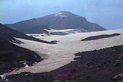
rock up the side of the second ridge.I could finally see Hayden Glacier, where I was heading, and it
was going to take a couple of more ridges to make it over there, as I
had ended up over a mile south of my route.I considered heading up the southeast ridge of Middle Sister at
this point, which would have been much closer, but I had set up the
GPS for this route, researched this route with the little information
available, and I had told everyone I was going on this route, so for
safety’s sake, I decided I had better stick to the plan.
I descended the ridge, and
struggled up the next one.
I was again bummed to see that the slope leading down to the glacier
was very steep, consisting of loose rock.It looked dangerous, and I was nervous.However, I didn’t really see any other choice that was
reasonable at this point.
I traversed the slope, with rock falling with each step, trying not to
lose too much altitude, which now stood at around 7,600 feet.
...continued
on next page. Click the arrow below to continue.